

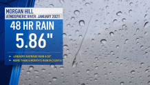
Rain in the Bay Area the past 2 years has been hard to come by at times and when we have had major rain totals it all points towards Atmospheric Rivers. One of the stronger AR’s we had in recent memory happened in January which brought 5.86” of rain to Morgan Hill in just 48 hours. That’s more rain in two days than we should have for the entire month of January!
While all of that rain sounds good, it is a weather extreme we could see more of in the future.
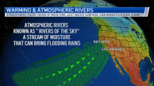
So what is an Atmospheric River or AR? It’s very simple, just as the name says it’s a river of the sky. A stream of warm, moist and often more humid air moving just above the surface. If the winds in the pacific steer these AR’s in just the right direction (see pic below) it can bring the Bay Area copious amounts of rain, especially to our mountains. If an AR stalls out and lingers, that’s when our flooding threat can be very high.
Get a weekly recap of the latest San Francisco Bay Area housing news. Sign up for NBC Bay Area’s Housing Deconstructed newsletter.
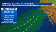
So, how could Atmospheric Rivers be changing in the future? New data shows that with continued warming to our air and oceans this will give more fuel to make AR’s stronger. In fact, AR’s could become 25% wider and longer, global frequency would increase by 50% and when they do occur our flooding risk would be higher.
You can find out more about how the Bay Area climate is changing in a series of stories the Microclimate Weather Team worked on across the Bay Area.
