
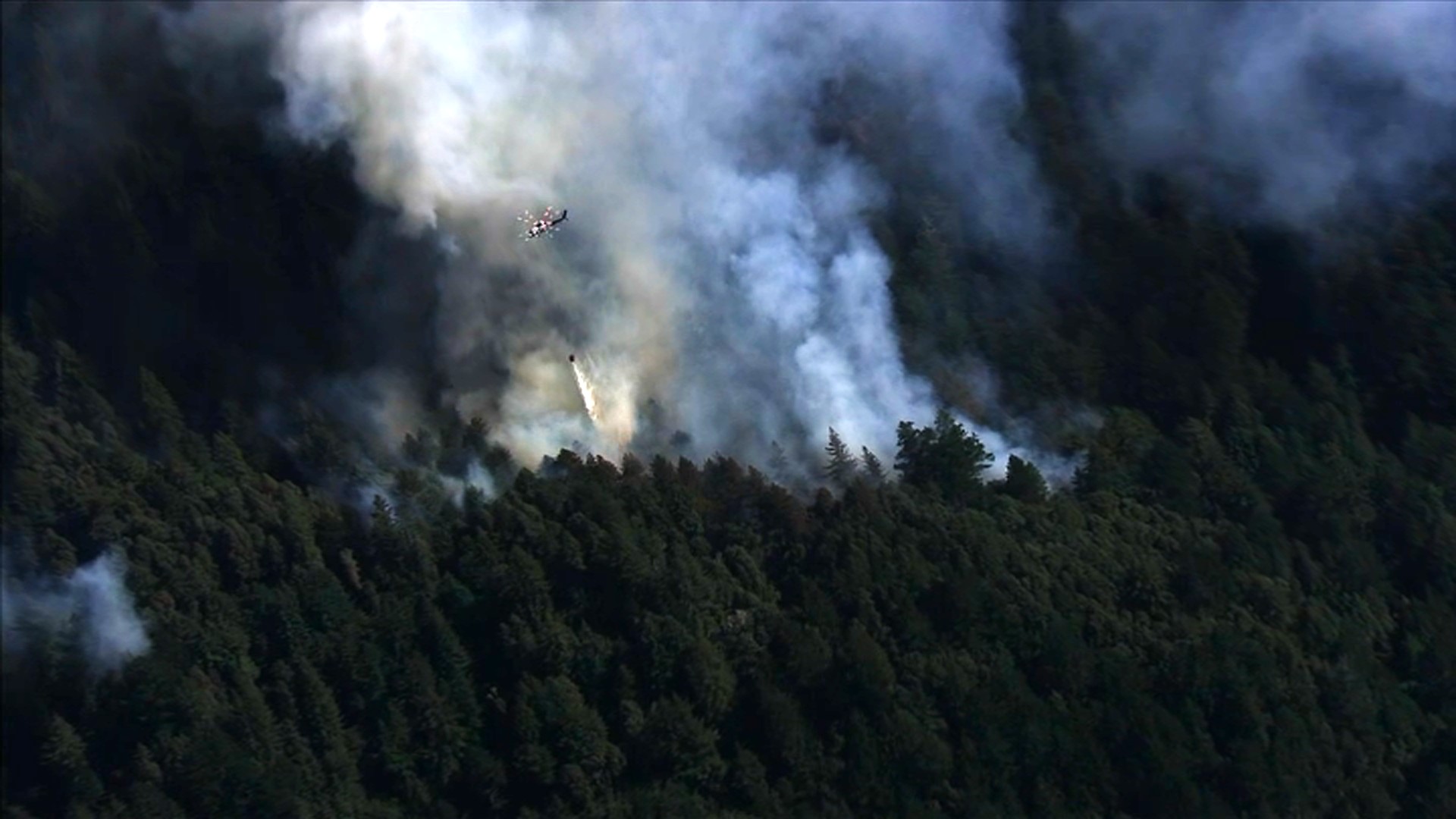
Dozens of lightning-sparked wildfires have forced tens of thousands of residents to leave their homes. Here's a breakdown of the current evacuation orders and warnings issued by officials.
Most recent alerts
Evacuation orders have been downgraded to warnings in the following areas of Santa Cruz County:
- Areas of Santa Cruz County to include portions of Boulder Creek:
- BOU-E020
- BOU-E021
- BOU-E022
- BOU-E030
- BOU-E031
- CRZ-E031C
More details here.
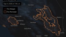
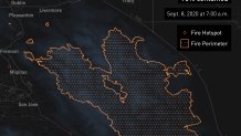
CZU Complex: San Mateo, Santa Cruz counties
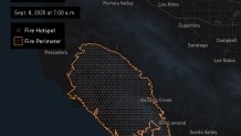
Santa Cruz County Evacuation Orders
- Waterman Gap Loop, Upper HWY 236, Boulder Creek Golf Course, Heartwood Hill, Lodge Road, Community of Little Basin, Lower China Grade, Upper China Grade, Community of Kings Hwy, Lower Jamison Creek, Gallion Heights, Fallen Leaf Neighborhood, Foxglove Lane (Zones CRZ10, CRZ13, BOU20, BOU30, BOU31, BOU36, BOU37, BOU21) (8/18/2020 10 pm)
- Saratoga Toll Road, San Lorenzo Park, Riverside Grove-Community of Teilh Drive, Wildwood Road (BOU38, BOU39, BOU40, BOU41, BOU42, BOU43) (8/18/2020 10 pm)
- Everyone on Empire Grade Road, from Felton Empire north, all of Pine Flat Road, all of Ice Cream Grade, Bonny Doon Road, in between Pine Flat Road, Martin Road, and all associated side streets are under an evacuation order. Areas west of State Route 35 from San Mateo County Line to State Route 17. (CRZ1, CRZ2, CRZ3, CRZ4, CRZ5, CRZ10, CRZ11, CRZ12, CRZ13) (8/19/2020 1:00 am)
- Bonny Doon south of Ice Cream Grade, to include Pine Flat Road South. (CRZ7, CRZ8) (8/19/2020 1:00 am)
- Bonny Doon south of Ice Cream Grade, to include Pine Flat Road South. (Zones: CRZ-7, CRZ-8, CRZ-6B,) (8/19/2020 1:00am)
- Areas of Alba Road, Hubbard Gulch and Fanning Grade. (BEN 1) (8/19/2020 6:00 pm)
- Area in BEN-2, specifically Valley View Road
- Areas of Boulder Creek (Zones: BOU-10B, BOU-14B, BOU-15B, BOU-16-19, BOU-22-24, BOU-35, CRZ-14C)
- Areas of Felton (FEL-3B)
Evacuation orders have been downgraded to warnings in the following areas of Santa Cruz County:
- Areas of Santa Cruz County to include portions of Boulder Creek:
- BOU-E020
- BOU-E021
- BOU-E022
- BOU-E030
- BOU-E031
- CRZ-E031C
Santa Cruz County Evacuation Warnings
- East edge of Bear Creek (Zones: BOU-8A, BOU-13, BOU-25, BOU-26, CRZ-14B)
- Areas in Boulder Creek and Brookdale (Zones: BOU-1-7, BOU-8B, BOU-9, BOU-9C, BOU-10A, BOU-11A, BOU-12, BOU-14A, BOU-15A, CRZ-9C, CRZ-11A, CRZ-13A, FEL-4B
- Black Ranch Road area (Zone:CRZ-9C)
- Big Basin Way (Zone: CRZ-13A)
San Mateo County Evacuation Orders
- Communities of Loma Mar and Dearborn Park Area (Zone: SMC-E018) (8/18/2020 5:00 pm)
- Pescadero Creek County Park Area (Zone SMC E024)) (8/18/2020 5:00 pm)
- Butano Community Area (Zone SMC E098) (8/18/2020 5:00 pm)
- Butano State Park Area including Barranca Knolls Community (Zone SMC E019) (8/18/2020 5:00 pm)
- Butano Creek Drainage (Zone SMC E055) (8/18/2020 4:30 pm) (8/18/2020 4:30 pm)
- South Skyline Blvd. Area near Highway 9 (SMC E049) (8/18/2020 11:00 pm)
- Western areas of San Mateo County (SMC-38, SMC-42)
San Mateo County Evacuation Warnings
- Areas in San Mateo County (Zone: SMC-49)
Evacuation Centers
- Santa Cruz County Fairground, 2601 E. Lake Ave, Watsonville
- Seventh Day Adventist Camp Grounds, 1931 Soquel San Jose Rd. (AT CAPACITY)
- Cabrillo College, 6500 Soquel Dr., Aptos
- Simpkins Family Swim Center, 919 17th Ave. (ADA only)
- Harbor High School, 300 La Fonda Ave., Santa Cruz

LNU Complex: Sonoma, Napa, Solano and Lake counties
Sonoma County Evacuations
Evacuation orders have been downgraded to warnings in the following areas of Sonoma County:
- South of Mill Creek Road
- North of Sweetwater Springs Road
- West of Westside Road
- East of Palmer Creek Road
For more details, click here.
Napa County Evacuations
All evacuation warnings in Napa County have been lifted. More details here.
Evacuation orders are in place for the following areas of Napa County:
- Highway 128 between Monticello Dam and Moskowite Corners (SR128/121 intersection) Wragg Canyon Markley Cove Pleasure Cove
- Highway 121 (Monticello Rd) Between Moskowite Corners(SR128/121 intersection) and Longhorn Ridge Road
- Highway 128 (Capell Valley Road/Sage Canyon Rd) from Chiles Pope Valley Road to Hwy 121 (Monticello Road) Steel Canyon Road Community of Berryessa Highlands Chiles and Lower Chiles Pope Valley Roads
- Berryessa-Knoxville Road from Hwy 128 (at Turtle Rock) to Lake County Line Community at Spanish Flat Loop Road Community of Berryessa Pines Both sides, including resorts and recreational areas of Lake Berryessa, Knoxville
- Atlas Peak Road from 3683 Atlas Peak Road (Circle R Ranch) to the dead end
- Howell Mountain Road from White Cottage Road east to Pope Valley Road
- All of Butts Canyon Road and connecting Roads in Napa County Snell Valley Road Stagecoach Road Community of Berryessa Estates
- Properties on the east side of Highway 29 between Silverado Trail and Lake County line Old Lawley Toll Road Palisades Road
An evacuation center has been established at Crosswalk Community Church, which is located at 2590 First St. in Napa. An animal evacuation center is located at the Napa County Animal Shelter at 942 Hartle Court in Napa.
Solano County Evacuations
Evacuation Order has been reduced to an Evacuation Warning. Only residents are permitted to re-enter the area with appropriate Identification.
Solano County begins phased repopulation process; helping residents safely return home after evacuation
Phase 1: This phase went into effect on August 27, 2020. This phase included residents who live in the areas West of Interstate 80 from Lyon Road to Vaca Valley Road, including Vaca Valley Road. Gates Canyon Road will remain closed. Phase 2: Today, August 28, 2020 phase 2 has gone into effect and includes the area north of Vaca Valley Road up to Cantelow Road and from Pleasants Valley Road to Gibson Canyon Road. Cantelow Road from Pleasants Valley Road to English Hills Road will remain closed. Mix Canyon Road will remain closed. Phase 3: Today, Phase 3 of the repopulation effort went into effect, and all County residents, including those in Phase 1 and 2, are able to return safely to their homes. Please note, a few roads will remain closed due to unsafe conditions, affecting approximately 60 properties.
For a map showing impacted areas and road closures, click here.
Lake County Evacuations
Evacuation orders downgraded to evacuation warnings LNU Lightning Complex Fire - Lake County:
- South of Butts Canyon Rd
- West of Callayomi Road
- East of Saint Helena Creek Road
- SR-29
Evacuation warnings lifted LNU Lightning Complex Fire - Lake County:
- South and West of Hwy 29
- West of Saint Helena Road
Evacuation orders are in effect for the following areas of Lake County:
- Hidden Valley Lake / Jerusalem Valley Areas
- North of Butts Canyon
- South of Hofacker Ln. to Morgan Valley Rd.
- East of Hwy 29
- West of Lake / Napa County line
- East of Middletown Area
- East of Hwy 29
- North of Lake / Napa County line up to the intersection of Hey. 29 and St. Helena Creek (Across from Twin Pine Casino)
- St. Helena Creek Rd
- South of Butts Canyon Rd.
- Lower Lake Area (South)
- East of Hwy. 29
- South of Morgan Valley Rd.
- West of Lake / Napa County line
- North of Hofacker Ln. extending east to Morgan Valley Rd. Lower Lake Area (North)
- North of Morgan Valley Rd.
- East of Sky High Ridge Rd. extending north to Hwy. 20
- South of Hwy. 20
- West of Lake / Napa / Colusa County lines
Evacuation warnings are in effect for the following areas of Lake County:
- Middletown Area
- West of Hwy. 29
- North and East of Lake / Napa
- South of Anderson Springs Rd. / Neft Rd. / Boggs Mt. Rec. Area extending northeast to Hwy. 29 / Hofacker Ln.
- Lower Lake Area
- East of Big Canyon Rd. / Perini Rd. / Seigler Canyon Rd.
- South and west of Hwy. 29
- North of the previous evacuation order / warning line of Anderson Springs Rd. / Neft Rd. / Boggs Mt. Rec. Area extending northeast to Hwy. 29 / Hofacker Ln.
Evacuation Centers/Temporary Evacuation Points
- Crosswalk Community Church, 2590 First Street, Napa
- Santa Rosa Fairgrounds, 1350 Bennett Valley Road, Santa Rosa
- Petaluma Veterans Building, 1094 Petaluma Blvd, South Petaluma
- Kelseyville High School parking lot, 5480 Main Street, Kelseyville
SCU Complex: Santa Clara, Alameda, Contra Costa, San Joaquin, Stanislaus, Merced and San Benito counties
Woodward Fire: Marin County
Evacuation orders have been issued in the following areas in Marin County:
- Silverhills
Evacuation warnings have been issued in the following areas in Marin County:
- Inverness Park
- NPS Park Headquarters at Bear Valley

For the latest on evacuation orders and warnings, click here. To see a map of the evacuation area, click here.
