
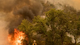
Firefighters continue to battle at least two large wildfires in Monterey County that have triggered evacuation orders.
The River Fire burning in the area of Pine Canyon and River Road, east of Salinas, has charred at least 48,732 acres and is 58% contained, Cal Fire said Thursday. The blaze has destroyed 30 structures and damaged 13 others. Four people, including fire personnel and civilians, have been hurt.
The Carmel Fire in the area of Cachagua and Carmel Valley roads, south of Carmel, has burned 6,767 acres, according to Cal Fire. It is 60% contained.
The flames have destroyed 73 structures and damaged seven more, Cal Fire said.
You can view a Cal Fire map of current incidents here.


River Fire Evacuations
Evacuation orders are in effect for the following areas:
- Zone 13*: To include all areas and roads east of Carmel Valley Rd to Palo Escrito Peak from south of Tassajara Rd to finch Creek not to include Carmel Valley Rd.
- Zone 14: All areas east of Carmel Valley Rd extending south from Finch Creek to Arroyo Seco Rd. All areas west of River Rd/Fort Romie Rd/Arroyo Seco Rd extending south to Elm Ave/Arroyo Seco Rd.
Evacuation centers have been set up at the Monterey Conference Center (1 Portola Plaza, Monterey) and the King City Branch Library (3404 Broadway Street, King City).
Evacuation shelters have been set up at Carmel Middle School in Carmel and the Salinas Valley Fairgrounds in King City.
Carmel Fire Evacuations
Evacuation orders are in effect for the following areas:
- Zone 1: East of Cachagua Road between Sky Ranch and Via Cielo, including Sky Ranch, Tributaries, and Via Cielo.
- Zone 2: Cachagua Road from Summerhill Road including via Cielo, Ridgeback Road, Sycamore Road, Summerhill Road and tributaries.
- Zone 3: Nason Road South from Cachuaga Road.
- Zone 4: Cachagua Road from Asoleado Drive to Tassajara Road to include Asoleado Drive, Comsat Road, Trampa Canyon Road and all tributaries.
- Zone 6: East of East Carmel Valley Rd at Tassajara Rd to Cahoon Ranch Rd to include Martin Rd and Cahoon Ranch Rd.
- Zone 7A: Includes the area and roads on Cachagua Rd south / west on Carmel Valley Rd including Ridgeback Rd, Buck Mountain Rd, and Sky Ranch.
- Zone 8AA: The forested unpopulated areas east of San Clemente Reservoir south along Carmel River and Pine Creek to Big Pine Road and Los Padres Reservoir.
- River Zone 13: To include all areas and roads east of Carmel Valley Rd to Palo Escrito Peak from south of Tasajara Rd to Finch Creek not to include Carmel Valley Rd
- Zone 14: All areas south of Corral de Tierra Rd and Underwood Rd extending south to Tassajara Rd, not to to include Corral de Tierra Rd and Underwood Rd.
Evacuation centers have been set up at the Monterey Conference Center and the King City Branch Library.
Evacuation shelters have been established at Carmel Middle School and the Salinas Valley Fairgrounds.
