
The 2021 edition of the Sierra snowpack is soon expected to go to 0% of average (2% statewide as of May 25th) which shouldn't be a surprise given the intensity of the current drought combined with warmer than average temperatures.
It represents about 30% of the state's fresh water in a typical year, a critical reserve that continues to get less reliable especially since 2000 as the odds of having an average snowpack into June has decreased considerably.
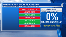
This coincides at a time where fire season length for the Sierra region is about 75 days longer than in the past (Source: Cal Fire), so we thought we would take a look back at snowmelt to 0% dates and how fire seasons associated with those years developed.
Get a weekly recap of the latest San Francisco Bay Area housing news. Sign up for NBC Bay Area’s Housing Deconstructed newsletter.
In years with below average precipitation and faster full snowmelt dates, wildfire fuels along streamflows and waterways tend to dry more rapidly. This provides an earlier start to fire season conditions and also in many instances, fire seasons trend longer due to drought conditions persisting into Fall even during the more traditional onset of our rain season.
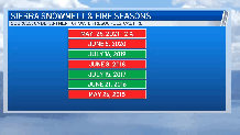
If you want to find examples of what a supersized snowpack vs. an extremely undersized one means in terms of fire season behavior, 2019 and 2020 provide some interesting examples.
Local
The Winter Snowpack in 2019 was among the largest and most sustained in the last 20 years with a 0% Sierra snowpack reading reached in mid July, well beyond the more typical mid-late June average. Not surprisingly, 2019 into Summer was the last of our average to above average precipitation periods combined with cooler than average temperatures. The 2019 fire season was one of the lowest on record with 259,823 acres burned, well below the five year average of roughly 446,960 acres burned per year.
As drought intensified however from Winter 2019 into 2020 fire season made an abrupt reversal to the worst on record with more than 4 million acres burned, enhanced by a longer fires season that started in Spring, and saw destructive growth as lightning sparked fires merged into large fire complexes from late August into September 2020.
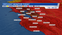
Fast forward to the current year and extreme to exceptional drought conditions continue across the Bay Area, with the North Bay into the East Bay at D4-or "Exceptional" drought, the highest on the drought monitor scale. Fire season has already been well underway with wildfire fuels at critically dry Summer-like levels as early as April. More "overwinter" fires also known as "zombie fires" where smoldering remnants of last year's lighting complex fires, briefly surge to short term growth again as the weather turns warmer and windier, as has been the case with the CZU Lightning Complex fire zone since the start of the year.
Current Sierra temperature and snowpack trends are mostly in line with climate change projections forecasting higher snow levels over time, with warming temperatures and drought becoming more common. As Sierra snow levels trend higher, total Sierra snowpack volume is expected to continue to decline with earlier melt seasons wrapping up before the end of Spring becoming more likely.
