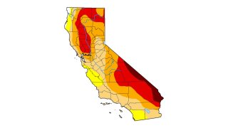
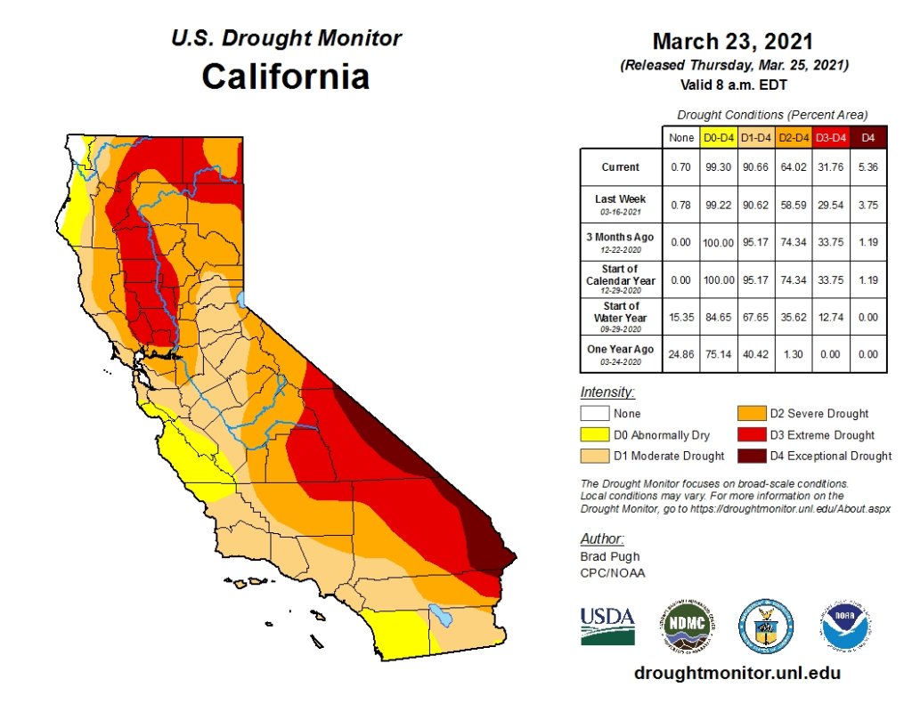
In California, the heaviest rain and snow comes in the winter months, but not this year. About 90% of the state already is experiencing drought conditions.
California's hopes for a wet "March miracle" did not materialize and a dousing of April showers may as well be a mirage at this point.
The state appears in the midst of another drought only a few years after a punishing 5-year dry spell dried up rural wells, killed endangered salmon, idled farm fields and helped fuel the most deadly and destructive wildfires in modern state history.
"We're looking at the second dry year in a row. In California that pretty much means we have a drought," said Jay Lund, a civil and environmental engineering professor at the University of California, Davis.
In fact, the entire West is gripped in what scientists consider a "megadrought" that started in 1999 and has been interrupted by only occasional years with above-average precipitation. In California, the heaviest rain and snow comes in the winter months, but not this year -- about 90% of the state already is experiencing drought conditions, according to the U.S. Drought Monitor.
The weekly drought monitor's next report is due out Thursday.
This U.S. Drought Monitor map shows conditions in California in late March 2021.
Much of California's water comes from mountain snow in the Sierra Nevada that melts during the spring and summer and feeds rivers and streams that in turn fill reservoirs. The Sierra snowpack traditionally holds its peak water content on April 1 and the state will take a survey Thursday to determine the level. Last month, a survey showed just 60% of the average.
Four years ago, when then-Gov. Jerry Brown officially declared an end to a statewide drought emergency, he said conservation should continue, warning "the next drought could be around the corner."
California Department of Water Resources
The results of California's annual snowpack surveys in the Sierra Nevada Mountains have been mixed over the decades.
NBC10 Boston
The California Department of Water Resources conducts a snow survey to measure the snowpack in the Sierras in El Dorado County in Northern California. Photo taken sometime during 1958.
California Department of Water Resources
California Department of Water Resources snow survey team right, Ray Barsch and Christopher Carr cross country ski to the Alpha test site, 7600 feet elevation in the Sierra Nevada mountain range near Forni Ridge and Lyons Creek in El Dorado County north of U.S. Highway 50. The water runoff from this area is part of the American River Watershed in Northern California. Photo taken April 11, 1967. Paul Weber / California Department of Water Resources, FOR EDITORIAL USE ONLY
California Department of Water Resources
Center, Frank Gehrke, chief of the California Cooperative Snow Surveys Program for the Department of Water Resources prepares for the monthly snow survey at Phillips Station in El Dorado County in the Sierra Nevada mountains. Photo taken March 2, 2009.
Telemundo
Right, Frank Gehrke, chief of the California Cooperative Snow Surveys Program for the Department of Water Resources leads the way to conducts the monthly snow survey during a snow storm at Phillips Station in El Dorado County in the Sierra Nevada mountains. Photo taken March 3, 2010.
Kelly Grow / California Department of Water Resources
Frank Gehrke conducts California Department of Water Resources monthly snow survey at Phillips Station near Echo Summit on December 30th, 2014.
California Department of Water Resources
The mountains at Phillips Station near Echo Summit on January 3, 2014.
CADWR
Frank Gehrke (DWR Chief of Snow Surveys) addresses the media during a snow survey at Phillips Station on April 1, 2015. The black tag on the pole is where the snow was in the drought year of 1977, the yellow tag is where the snow was the year before, and the green tag is where the snow is on an average year.
The Department of Water Resources (DWR) conducts a snow survey at Phillips Station on April 1, 2015. Measurements in Phillips began in 1942, and this report marked the first time there was zero snow for an April 1 measurement. Below-normal precipitation, combined with unusually warm weather, produced meager snowfall during the traditional wet season.
California Department of Water Resources
Right, Frank Gehrke, chief of the California Cooperative Snow Surveys Program for the Department of Water Resources, conducts the monthly snow survey at Philips Station.
California Department of Water Resources
Members of the California Council on Science and Technology Science Policy Fellows left to right, Michael Peterson, Julianne McCall and Mikel Shybut assist Frank Gehrke Chief of the California Cooperative Snow Surveys Program with the second snow survey of the 2017 snow season at Phillips Station in the Sierra Nevada Mountains. The survey site is approximately 90 miles east of Sacramento off Highway 50 in El Dorado County. Photo taken February 2, 2017.
Dale Kolke / California Department of Water Resources
The third snow survey of the 2017 snow season at Phillips Station in the Sierra Nevada Mountains. The survey site is approximately 90 miles east of Sacramento off Highway 50 in El Dorado County. Photo taken March 1, 2017.
California Department of Water Resources
A snow-covered Sierra Nevada mountain peak to the northwest from the Phillips Station meadow where the California Department of Water Resources conducted its third snow survey of the winter 2017 season. Photo taken March 1, 2017.
California DWR
A view of the Phillips Station site on Jan. 3, 2018 before the first snow survey of the season.
California DWR
A view of Phillips Station in the Sierra Nevada Mountain Feb. 1, 2018 during the second snowpack survey of the year.
CA DWR
A view of Phillips Station in the Sierra Nevada Mountains ahead of the third manual snow survey of 2018. The same meadow had just 7 percent of its usual snowfall a couple of weeks ago. A big winter storm a week earlier brought that up to 39 percent.
California Department of Water Resources
Frank Gehrke, Chief of the California Cooperative Snow Surveys Program leads the way to conduct the fourth snow survey of 2018 at Phillips Station in the Sierra Nevada Mountains. The survey site is approximately 90 miles east of Sacramento off Highway 50 in El Dorado County. Photo taken April 2, 2018.
California Department of Water Resources
John King, Water Resource Engineer, of the California Department of Water Resources, prepares to insert the long aluminum snow depth survey pole into the snow for the third media snow survey of the 2019 season at Phillips Station in the Sierra Nevada Mountains. The manual survey recorded 113 inches of snow depth and a snow water equivalent of 43.5 inches -- more than double the previous month.
California Department of Water Resources
John King, Water Resource Engineer, DWR Snow Survey Section, leads the fourth snow survey of water year, followed by team of members of DWR's excecutive staff. The survey showed snow water equivalent at 200 percent of average for the site.
California DWR
The third snow survey of the season is conducted March 2, 2021.
California DWR
California’s Jan. 3, 2023 snow survey in the Sierra Nevada Mountains.
It's arrival will mean different things depending on where people live.
The 2012-2016 drought required some sacrifice from everyone as Brown ordered a 25% reduction in water use. Residents took shorter showers, flushed less frequently and let their cars get dirty. Many homeowners replaced their lawns with artificial grass or desert succulents.
Such restrictions are less likely this time around because municipal supplies are in better shape and water use has not returned to previous levels, said Caitrin Chappelle of the Public Policy Institute of California. The Metropolitan Water District, which sells water to public agencies serving about half the state's 40 million residents, has a record high water supply.
But efforts to restore depleted groundwater aquifers or keep river flows high and water temperatures low enough for the winter-run Chinook salmon that almost went extinct on the Sacramento River during the drought, are not as far along.
"The time in between the end of the last drought and, possibly, the beginning of this next one isn't that long," Chappelle said. "They have started doing a better job of planning for it, it's just whether or not they've had enough time to prepare before the emergency hits again."
The Sierra snowpack provides about 30% of California's water and the Department of Water Resources measurement is key to forecasting how much can be allocated to farms and municipalities under a complex system of water rights laws that spell out what each user is entitled. The department already warned 40,000 water rights holders they will probably only get 5% of the amount they requested.
CA DWR
Right, a serpentine stretch of the California Aqueduct in Palmdale, Calif. within Los Angeles County at mile post 327.50. Photo taken February 7, 2014. Left, part of the Sierra Nevada Mountains.
California Department of Water Resources
Before we get to the California Aqueduct, here's where California's water lifeline starts -- a snow-covered Sierra Nevada mountain peak. This view is to the northwest from the Phillips Station meadow where the California Department of Water Resources conducted its third snow survey of the winter 2017 season. Photo taken March 1, 2017.
AP
Here's a look at conditions in the Sierra Nevada, Thursday, March 30, 2017, near Echo Summit, Calif. The location is where the California Department of Water Resources holds its manual snow survey at nearby Phillips Station. In late March 2017, the water content was at 183 percent of normal.
AP
The snowpack is so important, California water resources managers keep a close eye on it. Frank Gehrke, right, chief of the California Cooperative Snow Surveys Program for the Department of Water Resources, lifts the survey tube out of the snowpack depth during the manual snow survey at Phillips Station, Thursday, March 30, 2017.
AP
Water from snowmelt cascades down the South Fork of the American River on May 1, 2017, near Echo Summit. The warming springtime temperatures in California melt the state's snowpack, sending water into rivers and streams from the Sierra Nevada Mountains. (AP Photo/Rich Pedroncelli)
California Department of Water Resources
When the mountain snow melts, it runs downhill in rivers and stream, eventually ending up in the State Water Project. This view is looking north from the California Aqueduct Vista Point, an exit off the southbound 5 Freeway near Exit 423/Stuhr Road in Stanislaus County west of the Sierra Nevada range. Photo taken March 4, 2013.
California Department of Water R
Another view looking north from the California Aqueduct Vista Point in Stanislaus County. This photo was taken July 23, 2015, two years after the previous image during California's recent dry spell.
Paul Hames / California Department of Water Resources
This is an aerial view of the California Aqueduct near Tracy, California. It is the location of a 108-inch diameter interconnect pipeline in the ground between the California Aqueduct, to the left, and the Delta-Mendota Canal, which is part of the Central Valley Project. Photo taken April 20, 2012.
California Department of Water R
Another aerial view of the "intertie" constructed between the Delta-Mendota Canal and the California Aqueduct near Tracy. Photo taken April 20, 2012. Paul Hames / The California Department of Water Resources
John Chacon / California Department of Water Resources
The California Aqueduct is pictured in Alameda County, just north of the Bethany Reservoir.
California Department of Water R
As we head south, the California Aqueduct runs through the brown, dry hills of Newman in July 2015.
California Department of Water Resources
A pastel sky over the California Aqueduct in the San Joaquin Valley. Photo taken April 10, 2014.
AP
This undated file photo released by the California Department of Water Resources shows water making its way south through the Central Valley by way of the California Aqueduct.
Getty Images
Part of the east branch of the California Aqueduct, which imports water from the Sierra Nevada Mountains.
Getty Images
The California Aqueduct passes through the Dos Amigos pumping plant on April 24, 2015 in Los Banos, California.
California Department of Water R
The California Aqueduct near Highway 166 south of Bakersfield. Photo taken December 13, 2012. Florence Low / California Department of Water Resources
California Department of Water Resources
In Kern County, the California Aqueduct is seen at sunset.
John Chacon / California Department of Water Resources
This moonlight view is looking south toward the Tehachapi Mountains in Kern County.
John Chacon / California Department of Water Resources
Twilight falls over Kern County and the California Aqueduct.
California Department of Water R
The California Aqueduct splits into the West Branch and East Branch as it travels into the Southern California region.
California Department of Water Resources
The California Aqueduct bifurcates in the West Branch and East Branch as it travels into the Southern California region at the border of Kern and Los Angeles Counties. Photo taken February 6, 2014.
Florence Low / California Department of Water Resources
Another view of the California Aqueduct as it separates into the East Branch (left) and West Branch (right). Photo taken February 6, 2014.
California Department of Water Resources
The California Aqueduct just north of the A.D. Edmonston Pumping Plant looking west. Photo taken 1992. Dale Kolke / California Department of Water Resources
Florence Low / California Department of Water Resources
Another stretch of the California Aqueduct East Branch in Palmdale. Photo taken on February 7, 2014.
California Department of Water R
Another view of the winding stretch of the California Aqueduct in Palmdale. Photo taken February 7, 2014.
Getty Images
The California Aqueduct carries water from the Sierra Nevada Mountains through the high desert communities north of Los Angeles.
Getty Images
The California Aqueduct carries water from the Sierra Nevada Mountains to southern California. A segment the aqueduct is pictured in May 2008 near Palmdale.
Getty Images
The California Aqueduct carries water from the Sierra Nevada Mountains to Southern California. This picture is near Palmdale in May 2008.
Getty Images
The California Aqueduct carries water from the Sierra Nevada Mountains in May 2008 through Palmdale to other parts of Southern California.
California Department of Water R
This stunning aerial image shows a serpentine stretch of the California Aqueduct in Palmdale. Photos taken on February 7, 2014. Florence Low / California Department of Water Resources, FOR EDITORIAL USE ONLY
CA Department of Water Resources
This aerial view looks north toward Pyramid Dam and Pyramid Lake located on Piru Creek in Los Angeles County. The reservoir provides emergency storage for deliveries from the West Branch Aqueduct. It's also a popular recreational site for Southern Californians. Photo taken May 9, 2014.
John Chacon / California Department of Water Resources
A warning sign along the California Aqueduct East Branch. This location is where Highway 138 crosses the Aqueduct near the community of Neenach in Los Angeles County. Photo taken April 25, 2013.
Getty Images
Another view of the Los Angeles Aqueduct, which carries water from the snowcapped Sierra Nevada Mountains to the Los Angeles area.
Getty Images
Separate from the California Aqueduct network is the the Los Angeles Aqueduct, built and maintained by the the LADWP. Unlike most of the water collected from the Sierras, the LA Aqueduct receives its water from runoff on the eastern side of the mountains. Here, it is seen with snowcapped Sierra Nevada Mountains in the background, carrying watter to major urban areas of southern California on May 9, 2008 near Lone Pine.
"Guys are in a really tough spot when they don't know what water's going to be available until the planting season, which is now," said Danny Merkley of the California Farm Bureau Federation.
With less water to draw from rivers and the state's intricate network of canals and aqueducts, farmers fallowed hundreds of thousands of additional acres.
Growers will likely do the same thing again, idling low-value row crops such as tomatoes, lettuce or onions, to commit their precious groundwater to high-value permanent crops like almonds, pistachios and wine grapes, Merkley said.
Tapping those wells could have ramifications for their neighbors. During the last drought, agribusiness was blamed for over-pumping groundwater, causing the land to sink and wells in some poor rural communities to go dry.
Lawmakers for the first time decided to regulate groundwater and require plans in the next two decades to stop over-pumping from aquifers. But groundwater levels have not fully recovered from the last drought with another looming.
In Tombstone Territory, an unincorporated area surrounded by orchards outside Fresno, three-quarters of the 50 homes lost their well water during the last drought, said Amanda Monaco of the Leadership Counsel For Justice & Accountability. Many residents are farmworkers who can't afford the $20,000 required to dig a deeper well.
"If we're headed back into a drought that means potential devastation for communities that we work with," Monaco said. "They're terrified that kind of thing could happen again."
Ray Cano was one of the first Tombstone residents to lose his well water in 2015.
"It started spitting air and then nothing came out of it," Cano said.
His next door neighbor ran a hose over while Cano had his pump replaced and lowered deeper in the well. Cano returned the favor later that year when the neighbor's well dried up. Even now that their wells are working, the water quality is so poor that residents are provided 50 gallons (190 litres) of drinking water a month under a grant.
With less snow and temperatures warming due to climate change, another bad fire season is likely on the way, said Daniel Swain, a climate scientist at the University of California, Los Angeles.
The state largely escaped fire devastation during the previous drought, but has suffered terribly since, after 100 million trees died and vegetation remained dry as a result of the drought. Since 2015, the state has experienced the largest, most destructive and deadliest fires in recorded state history;
Lund found that the drought caused about $10 billion in damages statewide, without direct loss of life. But the wildfires after caused a record of over $55 billion in direct property losses and 175 direct deaths, with possibly many other deaths and economic impacts due to weeks of widespread air pollution from smoke.
"The interesting thing about these other drought impacts is they happened after the drought ended," Lund said.