How Dismal Is California's Snowpack? These Photos Tell a Grim Story
January and February are typically California's wettest months, when snowstorms replenish the Sierra Nevada snowpack
By Jonathan Lloyd •
NWS
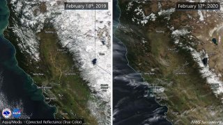
These side-by-side photos show California’s snowpack in February 2019 and February 2020.
Side-by-side satellite photos show the difference a year can make when it comes to California's vital snowpack in Sierra Nevada Mountain range.
The photos show the mountains covered in snow at this time last year following a conveyor belt of storms that brought steady snowfall throughout the winter. A photo taken Feb. 17 of this year illustrates the dreadful condition of the snowpack, which provides water for about 30 percent of California.
What a difference a year makes! Left: 2019, Right: 2020. Sierra snow pack is below normal for this time of year, at about 58% statewide. Dry weather is expected to continue. #CAwxpic.twitter.com/yjxR5JceCp
Ideally, a barrage of storms blanket the mountains in snow during winter. That snowpack then melts in warmer months and water flows into the state's vast system of reservoirs and aqueducts.
The snowpack is at 53 precent of normal for this time of year.
Last year at this time, the statewide snowpack was 127 percent of average. By the time the final snowpack survey of 2019 was taken, it was nearly double its average for early May after a series of winter storms pounded the West Coast.
January and February are historically the wettest months of the year in California. But that hasn't been the case in 2020 with a dry weather pattern dominating the state since the start of January.
California Department of Water Resources
The results of California's annual snowpack surveys in the Sierra Nevada Mountains have been mixed over the decades.
NBC10 Boston
The California Department of Water Resources conducts a snow survey to measure the snowpack in the Sierras in El Dorado County in Northern California. Photo taken sometime during 1958.
California Department of Water Resources
California Department of Water Resources snow survey team right, Ray Barsch and Christopher Carr cross country ski to the Alpha test site, 7600 feet elevation in the Sierra Nevada mountain range near Forni Ridge and Lyons Creek in El Dorado County north of U.S. Highway 50. The water runoff from this area is part of the American River Watershed in Northern California. Photo taken April 11, 1967. Paul Weber / California Department of Water Resources, FOR EDITORIAL USE ONLY
California Department of Water Resources
Center, Frank Gehrke, chief of the California Cooperative Snow Surveys Program for the Department of Water Resources prepares for the monthly snow survey at Phillips Station in El Dorado County in the Sierra Nevada mountains. Photo taken March 2, 2009.
Telemundo
Right, Frank Gehrke, chief of the California Cooperative Snow Surveys Program for the Department of Water Resources leads the way to conducts the monthly snow survey during a snow storm at Phillips Station in El Dorado County in the Sierra Nevada mountains. Photo taken March 3, 2010.
Kelly Grow / California Department of Water Resources
Frank Gehrke conducts California Department of Water Resources monthly snow survey at Phillips Station near Echo Summit on December 30th, 2014.
California Department of Water Resources
The mountains at Phillips Station near Echo Summit on January 3, 2014.
CADWR
Frank Gehrke (DWR Chief of Snow Surveys) addresses the media during a snow survey at Phillips Station on April 1, 2015. The black tag on the pole is where the snow was in the drought year of 1977, the yellow tag is where the snow was the year before, and the green tag is where the snow is on an average year.
The Department of Water Resources (DWR) conducts a snow survey at Phillips Station on April 1, 2015. Measurements in Phillips began in 1942, and this report marked the first time there was zero snow for an April 1 measurement. Below-normal precipitation, combined with unusually warm weather, produced meager snowfall during the traditional wet season.
California Department of Water Resources
Right, Frank Gehrke, chief of the California Cooperative Snow Surveys Program for the Department of Water Resources, conducts the monthly snow survey at Philips Station.
California Department of Water Resources
Members of the California Council on Science and Technology Science Policy Fellows left to right, Michael Peterson, Julianne McCall and Mikel Shybut assist Frank Gehrke Chief of the California Cooperative Snow Surveys Program with the second snow survey of the 2017 snow season at Phillips Station in the Sierra Nevada Mountains. The survey site is approximately 90 miles east of Sacramento off Highway 50 in El Dorado County. Photo taken February 2, 2017.
Dale Kolke / California Department of Water Resources
The third snow survey of the 2017 snow season at Phillips Station in the Sierra Nevada Mountains. The survey site is approximately 90 miles east of Sacramento off Highway 50 in El Dorado County. Photo taken March 1, 2017.
California Department of Water Resources
A snow-covered Sierra Nevada mountain peak to the northwest from the Phillips Station meadow where the California Department of Water Resources conducted its third snow survey of the winter 2017 season. Photo taken March 1, 2017.
California DWR
A view of the Phillips Station site on Jan. 3, 2018 before the first snow survey of the season.
California DWR
A view of Phillips Station in the Sierra Nevada Mountain Feb. 1, 2018 during the second snowpack survey of the year.
CA DWR
A view of Phillips Station in the Sierra Nevada Mountains ahead of the third manual snow survey of 2018. The same meadow had just 7 percent of its usual snowfall a couple of weeks ago. A big winter storm a week earlier brought that up to 39 percent.
California Department of Water Resources
Frank Gehrke, Chief of the California Cooperative Snow Surveys Program leads the way to conduct the fourth snow survey of 2018 at Phillips Station in the Sierra Nevada Mountains. The survey site is approximately 90 miles east of Sacramento off Highway 50 in El Dorado County. Photo taken April 2, 2018.
California Department of Water Resources
John King, Water Resource Engineer, of the California Department of Water Resources, prepares to insert the long aluminum snow depth survey pole into the snow for the third media snow survey of the 2019 season at Phillips Station in the Sierra Nevada Mountains. The manual survey recorded 113 inches of snow depth and a snow water equivalent of 43.5 inches -- more than double the previous month.
California Department of Water Resources
John King, Water Resource Engineer, DWR Snow Survey Section, leads the fourth snow survey of water year, followed by team of members of DWR's excecutive staff. The survey showed snow water equivalent at 200 percent of average for the site.
California DWR
The third snow survey of the season is conducted March 2, 2021.
California DWR
California’s Jan. 3, 2023 snow survey in the Sierra Nevada Mountains.
Last week, about 46 percent of California was considered abnormally dry, according to the US Drought Monitor report. The weekly report noted that a swatch of the state's Central Valley has entered moderate drought.
The monitor's categories range from abnormally dry to the most severe exceptional drought.
Los Angeles is on pace for its fourth driest February on record, recording just a trace amount of rain this month.
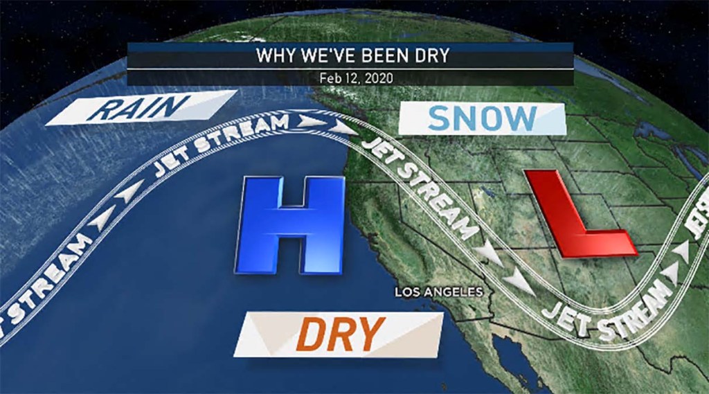
One main reason is that high pressure is blocking rain from moving into California and steering it toward the Pacific Northwest. The systems that would otherwise bring rain and snow are pushed too far north, which is especially bad news for the state's snowpack.
NBCLA
This map shows high pressure pushing storm systems to the north of Caifornia.
Snowpack typically peaks around the time of the April 1 survey, so there's still time for conditions to improve before the hot and dry summer months.
And, California has seen much worse during its history of prolonged dry spells followed drought busting wet winters. Consider February 2015, when more than 41 percent of California was in the most severe drought category. At that time, nearly all of the state was in moderate drought or worse.
That was just part of a years-long drought that was finally washed away by a series of powerful winter storms in 2017.