Cooling Changes Arrive
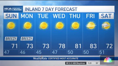
The return of coastal low clouds, mixed with mid and high level at times will help cool things down after a sunny, Summer-like weekend. Temps should remain in the 60s and 70s through midweek before our pattern shift turns to rain chances starting Thursday in the North Bay and spreading south into Friday morning. The Euro model brings as much as 2″-3″ into parts of the North Bay between Thursday-Sunday with lesser totals south of San Francisco. It does appear likely we’ll see rain totals roughly 200%-300% of average for this time of year if those totals can verify. Another system drops in midway through the weekend with slightly cooler air which should drop our first truly measurable snowfall in the Sierra by Sunday for elevations above 6-7,000′. Stay tuned as we try to narrow down on the timing and rain totals as the week progresses!