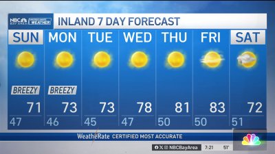
Mild Weekend
Areas of low clouds with some mist or local drizzle will be possible Into Sunday morning. We should see a similar finish to the day as we saw on Saturday with mid to upper 80s inland and cooler 60s and 70s around the Bay, with areas of low clouds lingering near the coast. Stronger high pressure will lead to a warm up next week with highs into the 70s around the bay with 80s and mid 90s possible inland. We could see a few Spare the Air days and an uptick to fire danger as inland temps stay warm to hot by day and fairly warm and dry around the hills overnight.
One added item to watch will be the first true appearance of the Summer monsoon into CA, with high clouds at times drifting our way from the south and southeast. Best chance for thunder remains to our south and east as things look right now but stay tuned.