Rob Mayeda: Weather Alert Through Sunday Night
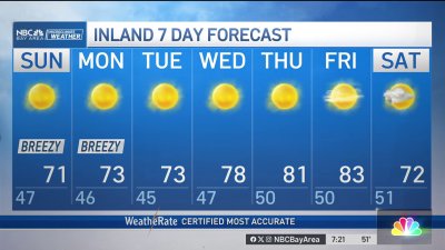
Despite some patchy fog and mist in areas to start the morning, we are expecting a spike in temperatures by midday into the afternoon with valleys seeing 90s and 100s and warm 70s-80s closer to the bay and coast. A Spare the Air alert is in effect for the weekend with highest air pollution levels near inland East Bay valleys. Sunday’s temps may dip slightly near the coast, while inland locations like the Tri-Valley and inland East Bay temps close to Saturday’s We’re banking on a sea breeze trending stronger into Monday, based on this timing highs by Monday afternoon should be considerably cooler on the scale of 10-15 degrees (or more) cooler inland…let’s hope that holds. In the meantime, remember to stay hydrated, adjust exercise or outdoor activities (in you’re in the valleys) to mid morning or evening this weekend. Based on the current timing of cooling, the heat advisory should expire by 11 p.m. Sunday.