Stormy Sunday Ahead
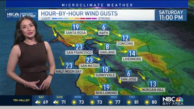
Plan on a windy start to Sunday with locally heavy rain at times and potentially a few strong thunderstorms as well as the day continues. Wind speeds of 20-40 mph out of the south/southeast with gusts above 50 will be possible especially near the coast and hills. Rain totals may not reach Friday/early Saturday’s storm…but the rain rates per hour will be a close match. This system is expected to move more quickly than the last so flooding threats look to be mainly localized in nature to urban and small stream areas.There is a risk for thunder both embedded within the frontal boundary moving through in the morning and in the post-frontal environment as strong directional shear aloft (WSW jet stream and S/SE winds at ground level) may allow stronger, rotating updrafts to develop. This is significant as it would allow thunderstorms to last longer, drop larger hail sizes and produce locally damaging wind gusts. Its not out of the question a few of the more intense cells may have enough rotation to form brief funnel clouds or tornadoes, especially in the Central Valley and areas to the east near inland Solano and Contra Costa counties. The atmosphere should begin stabilizing post-sundown with showers lingering into Monday but both the wind speed and rain coverage will be decreasing rapidly. High pressure will rebuild by Tuesday for a drier and warmer than average finish to the week. – Rob Mayeda