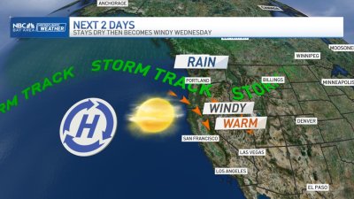
Videocast: Windy With Showers
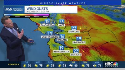
The weather is finally looking a little more like what the calendar is showing — a decent Winter blast moving through for Monday that will bring wind, some rain and lowering snow levels. Its looking like we’ll see winds in the 15-25 mph range throughout most of the lowlands and valleys with those speeds up to 35 mph near the coastline and hilltops. Some gusts in the hills could exceed 45 mph from midnight into early Monday afternoon.As this is a colder weather system detached from any real subtropical connection, we’re expecting rain totals to be on the low side – in the .25″ to .75″ in the coastal hills with generally less than .25″ elsewhere. Air aloft will turn quite chilly behind the front (you’ll notice the air mass change as NW winds kick in) that will mean less moisture available for showers yet temps cold enough aloft to drop snow levels near 3,500 to 4,000 ft. By Monday night and most of Tuesday its looking like we’ll stay dry with Tuesday night’s system still being the subject of debate among weather models – a few bringing us more showers, others just pushing the system away from the Bay Area which would mean zero showers. For now, we’ll call for a risk of some showers Tuesday night into Wednesday morning. Enjoy your Monday – Rob Mayeda