Wild Weather
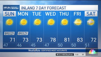
A cold upper level low coupled with daytime warming of the air below set off some strong convective showers and thundershowers on Saturday. Good enough to coat some hillsides or shall we say, hailsides in white. A briefly intense rotating cell prompted a severe thunderstorm warning for San Mateo County shortly before 7pm Saturday. Sunday begins much quieter and colder with lows dipping into the 30s for the wind sheltered inland valleys and cool 40s elsewhere. The low that brought the wild weather to the Bay Area will begin to weaken and move on, however it will still be close enough to us as the heating of the day continues to bring a chance for a few showers building near the hills of the South Bay, especially so for areas south of Morgan Hill.Another cold system dives down the coast for Monday, renewing the threat for briefly intense convective showers or thundershowers in similar locations during the afternoon. By Tuesday this system begins to move on with the showers gone and high pressure returning for breezy conditions and ahead to a warming trend for the second half of the week.- Rob Mayeda