Winter Blast Ahead
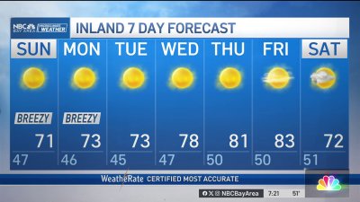
Temps will be mainly in the 60s for Monday as clouds increase into Tuesday. We’re expecting rain to develop overnight into Tuesday morning with wind speeds increasing throughout the day into the 15-30 mph range and higher gusts near the coast and hills. Rain should transition to scattered showers and isolated thundershowers at times. As even colder air begins to arrive, snow levels will approach closer to 3,000 feet into Wednesday morning. Showers should be on the decrease into Wednesday afternoon for travel plans around the Bay Area, but use caution heading into the Sierra where gusty winds and locally heavy snow will make travel tough. Drier weather is expected for Thanksgiving Day and Friday as our attention turns to the potential for freezing temps in the valleys.