
The back-to-back atmospheric river-fueled storms that pummeled California in recent weeks has created a temporary lake in an unusual location: Death Valley National Park, one of the driest and hottest places on Earth.
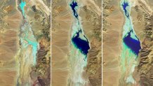
Satellite images released by NASA shows the lake forming in the Badwater Basin over several months, starting last year when Tropical Storm Hilary dumped a furious 2.2 inches of rain on Aug. 20, roughly the amount of rainfall the park usually receives in a year.
“Two inches of rain does not sound like a lot, but here, it really does stay on the surface,” Matthew Lamar, a park ranger, told The Associated Press at the time.
Get a weekly recap of the latest San Francisco Bay Area housing news. Sign up for NBC Bay Area’s Housing Deconstructed newsletter.
The lake that began to take shape after Hilary was 7 miles long, 4 miles wide and 2 feet deep, park officials said.
“Most of us thought the lake would be gone by October,” said Death Valley National Park ranger Abby Wines in a news release. “We were shocked to see it still here after almost six months."
And while some of the water evaporated and absorbed into the ground over the following months — shrinking to about half the size by January — when storms returned in February, the lake continued to expand as the rain runoff drained into the area.
U.S. & World

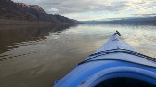
The temporary lake, informally known as Lake Manly, is about 6 miles long, 3 miles wide and 1 foot deep. Now, tourists are flocking to Death Valley National Park for an "extremely rare" opportunity to kayak.
“The lake was deep enough to kayak for a few weeks after Hurricane Hilary, but unfortunately people couldn’t come enjoy it then,” said Wines. “Every road in the park was damaged by flash floods, and it took two months to open the first road into the park. Now most of the main roads are open, so it’s a great time to come visit!”
Park officials say they don't know for how long the water will stick around, but believe it will create beautiful reflections through April.
Death Valley is a narrow, 282-foot basin that is below sea level but situated among high, steep mountain ranges, according to the park service’s website. The bone-dry air and meager plant coverage allows sunlight to heat up the desert surface. The rocks and the soil emit all that heat in turn, which then becomes trapped in the depths of the valley.
The park, which straddles eastern California and Nevada, holds the record for the hottest temperature recorded on the planet — 134 degrees Fahrenheit, reached in July 1913. During last summer's heatwave, temperatures climbed past 130 F in July. Hiking trails in summer months advise against venturing out after 10 a.m., though nighttime temperatures still hover over 90 F.
More than 1.1 million people visit the desert park annually. At 5,346 square miles, it’s the largest national park in the Lower 48.
The Associated Press contributed to this story.
