While the Bay Area only has the rare occurrence of tropical moisture making it here from a pacific hurricane, they do impact much of the United States.
There is also some takeaway from this new hurricane data and our west coast storms we’ll share later in this article.
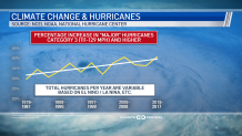
Overall, warming temperatures across the globe has had a direct impact on hurricanes. You can see in the data below the frequency of category 3 hurricanes has been on the increase since 1979, this is the same period of time when our temperatures have been steadily on the rise.
Get a weekly recap of the latest San Francisco Bay Area housing news. Sign up for NBC Bay Area’s Housing Deconstructed newsletter.
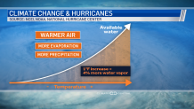
How does warmer temperatures relate to increased hurricane strength? Well, with warmer temperatures more evaporation is able to happen and this basically enables the air to hold much more water to feed a storm and keep it growing larger, eventually providing more rain and strength.
You can see the relation to temperature and water in our image below.
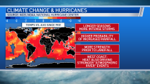
If temperatures keep warming we will be looking at longer hurricane season and more intense storms. There’s also a high probability of increased rain and more strength prior to landfall.
The takeaway for the Bay Area is the same principles described above with heat, evaporation and water driving stronger hurricanes, would also drive stronger "atmospheric river" events for the West Coast.
If you remember, atmospheric rivers can often bring flooding rains to the Bay Area. So, our future could also have more atmospheric rivers that are stronger as well. We covered this topic in more depth and you can get more in this link.
You can find out more about how the Bay Area climate is changing in a series of stories the Microclimate Weather Team worked on across the Bay Area.

