
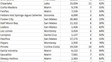
Almost two dozen Northern California cities and towns are at risk of gridlock in the event of an evacuation such as the ones ordered this past weekend because of the Kincade Fire, according to a recent analysis by the firm StreetLight Data.
The San Francisco company used geolocation data from 30,000 different cities with populations of less than 40,000 residents across the United States. StreetLight then tracked travel patterns of the towns’ residents and analyzed the number of exit routes for those communities to rank which could be most problematic in the event of a large-scale evacuation.
“We looked at the relationship between the number of people in a particular town and the number of routes out which we call exits,” said Martin Morzynski, vice president for StreetLight's marketing and product management.
Click here to see StreetLight Data's interactive map
StreetLight Data, which began its mapping project after a wildfire devastated Santa Rosa two years ago, is sharing its data with local cities and state officials in an attempt to improve evacuation strategies in towns with few exits.
“We can’t possibly act everywhere and act fast in preparing for whatever the next disaster might be,” Morzynski said. “But we can use this information to prioritize where to go first, where the potential danger is highest. That’s why we think this information is so powerful.”
The prospect of evacuating towns at a moment's notice is becoming a major concern as major wildfires sweep through California year after year, with climate change and population growth intensifying the risk.
Local


Some of these evacuations are becoming a safety hazard themselves as demonstrated last year during the Paradise fire when some residents died in their cars trying to get out of their community and flee the flames.
This past weekend saw the largest mass evacuation in Sonoma County’s history as tens-of-thousands of residents were told to leave home in face of the Kincade Fire. That evacuation clogged roads and forced thousands to sit for hours in their cars stuck in traffic jams on highways such as US 101.
Among the communities on the Kincade Fire mandatory evacuation list were Windsor and Bodega Bay. Both towns are also listed as among the 22 most problematic for evacuations in the greater Bay Area region, according to StreetLight Data’s analysis.
Even with the issues of clogged roads and headaches for motorists caused by people fleeing the region en masse, Windsor Mayor Dominic Foppoli called the evacuation of his town a great success. Foppoli said officials were able to evacuate the entire town by the deadline on extremely short notice.
Nationwide, StreetLight Data identified about 800 problematic communities and says it will help emergency planners such as Cal Fire to predict which towns could face evacuation traffic jams during a natural disaster or other mass evacuation event.
State lawmakers just passed a new law that requires local emergency planners to re-evaluate their evacuation plans by the end of 2020.
Governor Gavin Newsom said as part of that legislation, the state has set aside $75 million to pay to get the re-evaluation done and the new strategies in place.
The governor admits even more needs to be done to address these evacuation issues.
“It’s difficult. Some of these areas are rural. Some of these areas only have one core evacuation route,” Newsom said. “But we still have work to do in some of these evacuation areas. And that will continue to be a stubborn reality.”
