After the driest start to the year across much of Northern California, April saw the return to near average rainfall for areas north of San Francisco – this after many areas missed out on nearly 7 to 15 inches inches of rain from January through March.
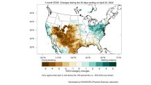
While the April rain totals weren't much, it appears the rain and the cooler temperatures have made a short term positive change when it comes to Bay Area fire danger and drought conditions.
A more active weather pattern helped lower drought severity near the North Coast and North Bay, however warmer and drier conditions around the Central Valley into Southern California allowed some increase in drought severity and fire danger.
Get a weekly recap of the latest San Francisco Bay Area housing news. Sign up for NBC Bay Area’s Housing Deconstructed newsletter.
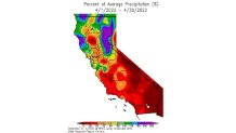
We also saw a large regional difference in precipitation and temperatures between Northern California and Southern California as well. Note how the Northern Sierra, especially areas north of I-80, had up to 200%-300% of average precipitation for April, while most of Central and Southern California saw below average numbers along with above average temperatures.
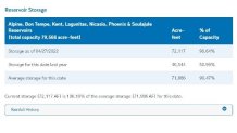
While the 2021-2022 rain season for the Bay Area has seen many cases of precipitation whiplash, for most regions we're currently faring better now when it comes to local reservoirs than the same time last year.
One year ago at the end of April, Marin Water reservoirs were at 50% capacity. Now they are close to 90% full a year later. While we saw considerably less rain near San Jose and the South Bay versus the North Bay, much of the reservoirs in the Valley Water district are ahead of the critically low levels they were at one year ago.
The short term reversal in fire danger and drought monitor severity may not last long, especially if the typically warmer temperatures in May and offshore wind events take hold. But, for now, most medium range forecasts to mid-month continue to show at least chances for some rain and high elevation snow for parts of Northern California.