

As our climate changes, warming temperatures is increasing thunderstorm potential for parts of the United Sates.
The map below is based on a weather tool we use called CAPE or Convective Available Potential Energy. Higher CAPE values indicate a higher chance of thunderstorm activity.
You’ll see since 1979 we are now averaging 20 to 40 more days of higher thunderstorm chances over the East, lower chances in parts of the Central U.S. and increased chances for parts of the West.
Specifically in California we now average 5 more t-storm days for parts of the North and East Bay along with the Central Valley.
Get a weekly recap of the latest San Francisco Bay Area housing news. Sign up for NBC Bay Area’s Housing Deconstructed newsletter.
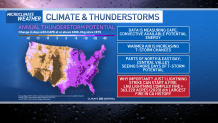
Why is this important? All it takes is just one lightning strike with our drought to spark a large fire. A key example of that is the LNU lightning complex in 2020 which grew to 363, 220 acres becoming the 6th largest fire in California’s history.
The good news, new research shows we can all make a difference help these consequences from getting worse with substantial cuts in emissions and greenhouse gases.
Local


This is something we can all participate in by lowering our carbon footprint. You can learn ways to lower your carbon footprint and details on all of our climate stories in this link.
