
Heavy rain and strong winds are back in the Bay Area forecast for Sunday.
Here's what you need to know about the latest storm system.
What to expect
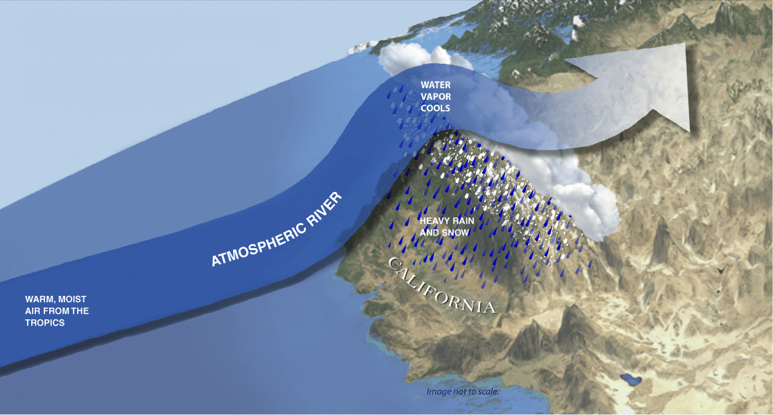
Another storm system packing heavy rain and gusty winds is slated to batter the Bay Area continuing into Sunday, according to the National Weather Service.
Get a weekly recap of the latest San Francisco Bay Area housing news. Sign up for NBC Bay Area’s Housing Deconstructed newsletter.
"An eastern Pacific low pressure system will draw deep subtropical moisture from Hawaii while also drawing in colder air from the northwest, the mixture producing a rapidly strengthening low pressure system upon arrival over our coastal waters late Saturday night & Sunday," the weather service wrote in a post on X.
Isolated severe thunderstorms are possible Saturday afternoon and early evening, the weather service posted on X, with the best chances being in the South Bay and Central Coast. It also warned that "damaging wind gusts and a tornado are possible."
Storm timeline
The weather service provided the following timeline for the storm:
- Monday morning - Monday night - Lingering showers (residual flooding)
- Tuesday and beyond: Lingering showers (waterways receding)
Forecasted rainfall totals
Here's a look at how much rain could fall between 4 a.m. Friday and 4 a.m. Monday, according to the weather service.
- Cloverdale: 2-3 inches
- Santa Rosa: 2-3 inches
- Napa: 2-3 inches
- Concord: 2-3 inches
- San Francisco: 2-3 inches
- Livermore: 1.5-2 inches
- San Jose: 2-3 inches
- Santa Cruz: 4-6 inches
- Hollister: 2-3 inches
- Monterey: 2-3 inches
- Big Sur: 4-6 inches
Flood watch
A flood watch has been issued for the Bay Area and Central Coast between 4 p.m. Saturday and 10 a.m. Monday. Santa Cruz and Santa Lucia Mountains are areas of particular concern Saturday, according to the National Weather Service.
People may encounter flooding along creeks, streams and rivers as well as on some roadways.
Hazardous winds
Strong winds are expected in the Bay Area and Central Coast.
A wind advisory has been issued for lower elevations of the North Bay as well as the rest of the Bay Area. Strong southerly winds with gusts up to 50 mph are expected.
A high wind warning has been issued for higher elevations in the North Bay, East Bay hills, South Bay hills, Santa Cruz Mountains and the Central Coast region. Strong southerly winds with gusts peaking at about 60 mph or higher are possible.
Both the wind advisory and high wind warning will be in effect from 10 p.m. Saturday until 10 p.m. Sunday.
Potential storm impacts
The weather service said the public should be prepared for the following storm-related issues:
- Rising creeks, rivers and streams
- Flooding along creeks, streams, and rivers and in urban areas
- Ponding on roadways and in low-lying areas
- Shallow landslides
- Downed branches and trees
- Power outages
Tracking the rain
Use our interactive radar below to track the storm.
Latest weather updates and forecast
Be sure to visit our weather page for detailed forecast information.
