

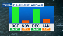
With our drought in place we certainly have had some good news this rain season as rain totals remain 150 to 200% of normal and snowpack is ranging from 125 to 135% of normal. While we remain above average now, the trend of rain has been extreme and it’s something known as “precipitation whiplash”.
You’ll see in the data below, October rain was well above average, followed by below average rain in November and then above average rain in December and now below average trend in January.
That’s the “precipitation whiplash” that’s being fueled by our changing climate.
Get a weekly recap of the latest San Francisco Bay Area housing news. Sign up for NBC Bay Area’s Housing Deconstructed newsletter.
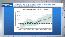
As our climate changes, the warming temperatures is fueling these extremes in our rainfall with higher chances of “Atmospheric Rivers” that can bring extreme rain. You’ll see in the next graph, since 2005 we’ve had a steady increase in extreme rain events.
If temperatures keep warming this trend could keep increasing into the year 2075.
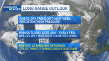
So, what about our rain chances ahead? I’m calling for a 65% chance we’ll see the weather trend swing back to more of a wetter weather pattern by the end of January into February. This would again be another extreme turn in our rain season. Much welcomed with the drought but certainly a sharp turn.
The good news, new research shows we can all make a difference and avoid increasing consequences with substantial cuts in emissions and greenhouse gases. This is something we can all participate in by lowering our carbon footprint.
Local

You can find out more about our changing climate and all of our stories in this link.
